Topic earth perimeter: Understanding Earth's perimeter is crucial for comprehending our planet's size and shape. This article explores historical and modern measurement techniques, differences between equatorial and polar circumferences, and their significance in various fields. Dive in to discover fascinating facts and practical applications of Earth's dimensions.
Table of Content
- Earth's Perimeter and Circumference
- Introduction to Earth's Perimeter
- Historical Measurement Techniques
- Modern Measurement Methods
- Equatorial Circumference
- Polar Circumference
- Equatorial vs Polar Diameter
- Calculations and Formulas
- Comparative Planetary Sizes
- Physical Characteristics and Shape
- Significance of Earth's Measurements
- Interesting Facts About Earth's Dimensions
- Impact on Global Navigation and Mapping
- FAQs on Earth's Circumference
- Practical Applications of Earth's Measurements
- Conclusion
- YOUTUBE: Xem video để hiểu cách Eratosthenes tính toán chu vi của Trái Đất bằng cách sử dụng ánh sáng mặt trời và các khái niệm toán học cơ bản. Có phù hợp với nội dung về chu vi Trái Đất hay không?
Earth's Perimeter and Circumference
The perimeter of Earth, more commonly referred to as the circumference, can be measured in two primary ways: around the equator and around the poles. This is due to the Earth not being a perfect sphere but an oblate spheroid, which means it is slightly flattened at the poles and bulges at the equator.
Equatorial and Polar Circumference
- The equatorial circumference of Earth is approximately 40,075 kilometers (24,901 miles).
- The polar circumference, which is the measurement around the poles, is slightly less, at about 40,008 kilometers (24,860 miles).
The difference in these measurements is caused by the Earth's rotation, which causes the equator to bulge out slightly.
Diameter of the Earth
The diameter of Earth also varies slightly depending on where it is measured:
- Equatorial diameter: approximately 12,756 kilometers (7,926 miles)
- Polar diameter: approximately 12,714 kilometers (7,900 miles)
Mathematical Calculation
To calculate the circumference of Earth, the following formula is used:
\[
C = 2 \pi r
\]
where \( C \) is the circumference, \( \pi \) is a constant (approximately 3.14159), and \( r \) is the radius of Earth.
Given the average radius of Earth is about 6,371 kilometers (3,959 miles), the calculation for the equatorial circumference is:
\[
C = 2 \times 3.14159 \times 6,371 \approx 40,075 \text{ kilometers}
\]
Interesting Facts
- Earth is the fifth largest planet in our solar system.
- Earth's surface is 70.8% water and 29.2% land.
- The highest point on Earth's surface is Mount Everest at 8,848 meters (29,029 feet) above sea level.
- The lowest point on Earth's surface is the Mariana Trench at 11,034 meters (36,200 feet) below sea level.
Historical Measurement
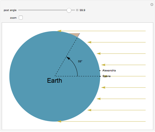
The first known accurate measurement of Earth's circumference was conducted by the Greek mathematician Eratosthenes around 240 BC. He used the angles of shadows in two different cities (Syene and Alexandria) to calculate the Earth's circumference with remarkable accuracy for his time.
Today, modern measurements using satellite technology have refined our understanding of Earth's dimensions, but Eratosthenes' methods remain a testament to early scientific ingenuity.

READ MORE:
Introduction to Earth's Perimeter
The perimeter of Earth, commonly referred to as its circumference, is a fundamental measurement that reveals much about our planet's size and shape. Earth is not a perfect sphere but an oblate spheroid, meaning it has a slight bulge around the equator. This characteristic affects its circumference, which varies depending on the measurement path.
The circumference at the equator is approximately 40,075 kilometers (24,901 miles), while the polar circumference is slightly less at about 40,007 kilometers (24,860 miles). These variations occur because the equatorial diameter is greater than the polar diameter due to the centrifugal force generated by Earth's rotation.
The calculation of Earth's circumference can be understood through the formula for the circumference of a circle: \(C = 2 \pi r\), where \(r\) is the radius. Given that the Earth's equatorial radius is about 6,378 kilometers (3,963 miles), applying this formula provides the equatorial circumference. The polar radius is slightly shorter, contributing to the reduced polar circumference.
Historically, the first accurate measurement of Earth's circumference was performed by the Greek mathematician Eratosthenes around 240 BCE. Using simple geometric principles and observations of the angles of shadows in different locations, he estimated Earth's circumference to be remarkably close to modern measurements.
- The equatorial circumference: 40,075 km (24,901 miles)
- The polar circumference: 40,007 km (24,860 miles)
These measurements are crucial not only for understanding Earth's dimensions but also for various practical applications, including navigation, mapping, and satellite communications.
Historical Measurement Techniques
Understanding the Earth's perimeter has fascinated scholars for centuries. Ancient civilizations employed various techniques to measure the Earth's circumference, with notable contributions from Greek astronomers and mathematicians. Here are some key historical measurement techniques:
-
Eratosthenes' Method (3rd Century BC):
Eratosthenes, a Greek scholar, used a simple yet ingenious method to estimate the Earth's circumference. He measured the angle of the shadow cast by a stick in Alexandria and compared it to the shadow in Syene (modern Aswan) at the same time on the summer solstice. By knowing the distance between these two cities and the angle difference, he calculated the Earth's circumference as approximately 40,000 km, remarkably close to modern measurements.
Distance between Alexandria and Syene 5,000 stades Angle of shadow in Alexandria 7.2 degrees Calculated Earth's circumference 250,000 stades (approximately 40,000 km) -
Posidonius' Method (1st Century BC):
Posidonius, another Greek philosopher, used observations of the star Canopus from different latitudes to estimate the Earth's size. He calculated the Earth's circumference to be about 29,000 km, which was less accurate than Eratosthenes' estimate.
-
Al-Biruni's Method (10th Century AD):
Al-Biruni, a Persian scholar, developed a method using trigonometric calculations and observations from mountain tops. He measured the angle between the horizon and a peak from a known distance and used this data to calculate the Earth's radius. His results were also remarkably accurate, demonstrating advanced knowledge of geometry and trigonometry.
These historical measurement techniques laid the foundation for our modern understanding of the Earth's size and shape, showcasing the ingenuity and scientific curiosity of early scholars.
Modern Measurement Methods
Modern measurement methods of Earth's perimeter involve a variety of advanced techniques that provide highly accurate results. These methods leverage satellite technology, GPS, and sophisticated mathematical models.
- Satellite Geodesy: Satellites equipped with geodetic instruments orbit the Earth and provide precise measurements of its shape and size. These satellites use radio waves to measure the distance between the satellite and various points on Earth’s surface.
- Global Positioning System (GPS): GPS technology relies on a network of satellites that send signals to receivers on Earth. By calculating the time it takes for the signals to travel from the satellites to the receivers, the system can determine precise locations and distances on Earth.
- Very Long Baseline Interferometry (VLBI): This technique involves using radio telescopes located far apart to observe quasars and other celestial objects. By comparing the time it takes for the radio waves to reach different telescopes, scientists can measure the distances between the telescopes with great accuracy, which in turn helps determine the Earth’s dimensions.
- Laser Ranging: In this method, lasers are used to measure the distance between the Earth and satellites or the Moon. The time it takes for the laser to travel to the target and back is used to calculate the distance, which helps refine measurements of the Earth’s size and shape.
These methods have greatly improved our understanding of Earth's perimeter, providing measurements with minimal errors and contributing to various scientific and practical applications.
Equatorial Circumference
The equatorial circumference of Earth is an essential measurement in understanding our planet's dimensions. This circumference is the distance around Earth measured along the equator, which is approximately 40,075 kilometers (24,901 miles). This measurement is crucial because the Earth is not a perfect sphere but an oblate spheroid, meaning it is slightly flattened at the poles and bulges at the equator.
Several factors influence the equatorial circumference:
- Rotation: The Earth's rotation causes a centrifugal force, making the equator bulge outwards.
- Shape: As an oblate spheroid, the Earth's equatorial circumference is larger than its polar circumference.
The equatorial circumference has various implications:
- Gravitational Force: Gravity is slightly weaker at the equator compared to the poles due to the centrifugal force from rotation.
- Climate: The equatorial bulge affects climate patterns and the Coriolis effect, which influences wind and ocean currents.
- Satellite Launch: Satellites are often launched from near the equator to take advantage of the Earth's rotational speed, which provides an extra boost.
The equatorial circumference is significant not only for scientific understanding but also for practical applications such as global navigation, climate studies, and space exploration.

Polar Circumference
The polar circumference of the Earth, which is the distance around the Earth measured from one pole to the other and back, differs slightly from the equatorial circumference due to the Earth's oblate spheroid shape. This shape means the Earth is slightly flattened at the poles and bulges at the equator.
The polar circumference of Earth is approximately 40,008 km (24,860 miles). This measurement is derived from the Earth's polar radius, which is shorter than the equatorial radius. The polar radius is approximately 6,357 km (3,950 miles), compared to the equatorial radius of about 6,378 km (3,963 miles).
To understand these measurements, it's important to note that the Earth's shape results from the centrifugal force caused by its rotation. This force pushes outwards at the equator, making it bulge, and pulls inwards at the poles, causing them to flatten slightly.
| Type | Measurement |
|---|---|
| Equatorial Circumference | 40,075 km (24,901 miles) |
| Polar Circumference | 40,008 km (24,860 miles) |
These precise measurements are crucial for various applications, including satellite navigation, global positioning systems (GPS), and understanding Earth's geophysical properties. Advances in satellite technology and geodesy have allowed scientists to measure these dimensions with great accuracy, enhancing our comprehension of the planet's shape and size.
Equatorial vs Polar Diameter
The Earth's shape is not a perfect sphere but an oblate spheroid, meaning it is slightly flattened at the poles and bulging at the equator. This results in a difference between the equatorial and polar diameters.
The equatorial diameter of Earth is approximately 12,756 km (7,926 miles), while the polar diameter is about 12,713.6 km (7,899.86 miles). This difference of roughly 43 km (27 miles) is due to the centrifugal force caused by Earth's rotation, which pushes outwards at the equator.
- Equatorial Diameter: 12,756 km (7,926 miles)
- Polar Diameter: 12,713.6 km (7,899.86 miles)
- Difference: 43 km (27 miles)
This bulge at the equator also affects the distance from the Earth's center. Points along the equator are approximately 21 km (13 miles) further from the center of the Earth compared to points at the poles. This phenomenon influences various factors, including satellite launches, which are more efficient near the equator due to the higher rotational speed and lower gravitational pull.
Calculations and Formulas
Understanding the Earth's perimeter involves several important calculations and formulas, particularly when considering its circumference and diameters. Here, we will explore the methods used to determine these measurements, focusing on the essential mathematical principles.
Calculating the Circumference
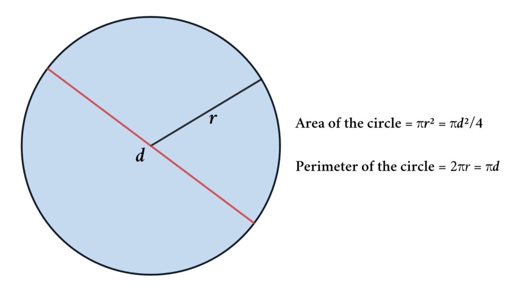
The circumference of a sphere, such as Earth, can be calculated using the formula:
\[
C = 2 \pi r
\]
where \( C \) is the circumference and \( r \) is the radius of the sphere.
For Earth, the average radius is approximately 6,371 kilometers, leading to the following calculation for the equatorial circumference:
\[
C = 2 \pi \times 6,371 \approx 40,075 \text{ kilometers}
\]
Calculating the Diameter
The diameter of a sphere is twice its radius:
\[
D = 2r
\]
Thus, for Earth, the diameter is approximately:
\[
D = 2 \times 6,371 \approx 12,742 \text{ kilometers}
\]
Ellipsoid Considerations
Because Earth is not a perfect sphere but an oblate spheroid, its equatorial and polar measurements differ slightly:
- Equatorial Circumference: 40,075 kilometers
- Polar Circumference: 40,008 kilometers
Example Calculation
To illustrate, let's use Eratosthenes' method for calculating Earth's circumference. He measured the angle of the sun's rays at noon in two different locations and used the distance between them:
\[
\theta = \frac{1}{50} \text{ of a circle} = 7.2^\circ
\]
\[
C = \frac{d}{\theta}
\]
where \( d \) is the distance between the two points. If \( d \) is 800 kilometers:
\[
C = \frac{800}{7.2^\circ / 360^\circ} \approx 40,000 \text{ kilometers}
\]
This simplified example shows how ancient techniques combined geometry with observational data to estimate Earth's size accurately.
Comparative Planetary Sizes
Understanding Earth's perimeter involves comparing its size to other celestial bodies. This helps contextualize Earth's dimensions within our solar system.
Below is a comparison of planetary sizes:
| Planet | Diameter (km) |
|---|---|
| Mercury | 4,880 |
| Venus | 12,104 |
| Earth | 12,742 |
| Mars | 6,779 |
| Jupiter | 139,820 |
| Saturn | 116,460 |
| Uranus | 50,724 |
| Neptune | 49,244 |
As seen in the table, Earth is the largest of the terrestrial planets but significantly smaller than the gas giants. For instance, Jupiter's diameter is about 11 times that of Earth.
To further illustrate, if Earth were the size of a nickel, Jupiter would be roughly the size of a basketball. This stark contrast in sizes underscores the diversity of planetary dimensions within our solar system.
Such comparisons highlight not only the uniqueness of Earth but also the vastness and variety of planetary bodies that orbit our Sun.
Physical Characteristics and Shape
The Earth is an oblate spheroid, meaning it is slightly flattened at the poles and bulging at the equator. This shape is due to the planet's rotation, which causes a centrifugal force that pushes the equatorial region outward.
The Earth's physical structure is divided into four main layers:
- Crust: The Earth's outermost layer, composed of solid rocks and minerals. It is thin compared to the other layers and varies in thickness from the oceanic crust (about 5-10 km) to the continental crust (up to 70 km).
- Mantle: Located beneath the crust, the mantle extends to a depth of about 2,900 km. It consists of semi-solid rock that flows slowly, driving plate tectonics.
- Outer Core: A liquid layer composed mainly of iron and nickel, extending from a depth of 2,900 km to 5,150 km. The movement of the liquid outer core generates Earth's magnetic field.
- Inner Core: The innermost layer, reaching a depth of about 6,371 km. It is solid due to immense pressure, despite high temperatures, and is also composed primarily of iron and nickel.
In terms of size, the Earth's equatorial circumference is about 40,075 km, while the polar circumference is approximately 40,008 km. This difference illustrates the equatorial bulge caused by rotational forces. The diameter at the equator is about 12,756 km, compared to 12,714 km at the poles.
Various physical characteristics such as mountain ranges, ocean basins, and continental shelves contribute to the Earth's diverse topography. The highest point on Earth is Mount Everest, at 8,850 meters above sea level, while the deepest part of the ocean is the Mariana Trench, at about 10,924 meters below sea level.
The Earth's unique combination of physical properties and its position in the solar system make it the only known planet to support life. Factors like the presence of water, a stable atmosphere, and a suitable climate are crucial for sustaining diverse ecosystems.
Significance of Earth's Measurements
The measurement of Earth's circumference and dimensions holds profound significance across various fields, ranging from geography to physics, navigation to cartography. Understanding the scale and shape of our planet enables us to:
- Geographical Studies: Accurate measurements of Earth's perimeter facilitate the study of geographical features, such as continents, oceans, and mountain ranges, aiding in the comprehension of Earth's surface dynamics.
- Climate Research: Earth's dimensions play a crucial role in climate modeling and understanding climate patterns globally, assisting scientists in predicting weather phenomena and assessing climate change impacts.
- Navigation: Knowledge of Earth's circumference is fundamental for navigation, both terrestrial and maritime. It forms the basis for creating accurate maps and charts, essential for safe travel and efficient transportation logistics.
- Space Exploration: Precise measurements of Earth's dimensions contribute to space missions, providing valuable data for spacecraft trajectories, orbital mechanics, and planetary exploration endeavors.
- Global Communication: Understanding Earth's size and shape aids in the design and implementation of communication networks, such as satellite systems and undersea cables, ensuring efficient global connectivity.
- Environmental Monitoring: Monitoring changes in Earth's dimensions over time helps assess environmental factors like land subsidence, sea level rise, and tectonic plate movements, crucial for disaster management and urban planning.
- Scientific Research: Earth's measurements serve as a reference point for various scientific studies, including astronomy, geology, and seismology, facilitating a deeper understanding of the universe and our place within it.
Overall, the significance of Earth's measurements extends far beyond mere numerical values, shaping our understanding of the planet and its interconnected systems, guiding both scientific exploration and practical applications for the betterment of society.
Interesting Facts About Earth's Dimensions
Exploring Earth's dimensions unveils fascinating insights about our planet's scale and structure. Here are some intriguing facts:
- Varied Circumference: Earth's equatorial circumference is approximately 40,075 kilometers (24,901 miles), while its polar circumference is slightly shorter at about 40,008 kilometers (24,860 miles), due to the flattening at the poles.
- Oblate Spheroid Shape: Despite its common depiction as a perfect sphere, Earth is an oblate spheroid, meaning it is slightly flattened at the poles and bulges at the equator, resulting in a more elliptical shape.
- Earth's Diameter: The average diameter of Earth is approximately 12,742 kilometers (7,918 miles), with variations due to the planet's topography and geological features.
- Geodetic Reference: Earth's dimensions serve as a standard reference for geodetic measurements worldwide, forming the basis for defining units of measurement like the meter and establishing global coordinate systems.
- Constant Change: While Earth's overall dimensions remain relatively stable over short time spans, factors such as tectonic movements, sea level changes, and glacial dynamics contribute to subtle variations in its shape and size over geological timescales.
- Planetary Comparisons: Understanding Earth's dimensions allows for comparisons with other celestial bodies, highlighting its uniqueness in terms of size, composition, and habitability within the solar system.
- Human Scale: Despite Earth's vast dimensions on a planetary scale, it's remarkable how interconnected and accessible our world has become, thanks to advancements in technology and transportation.
These facts not only showcase the sheer magnitude of Earth's dimensions but also inspire curiosity about the dynamic processes shaping our planet's form and function.
Impact on Global Navigation and Mapping
Earth's measurements have a profound impact on global navigation and mapping, influencing various aspects of modern life. Here's how:
- Accurate Positioning: Precise knowledge of Earth's dimensions enables the development of accurate positioning systems like GPS (Global Positioning System), which provide real-time location information for navigation on land, sea, and air.
- Map Creation: Understanding Earth's circumference and shape is essential for cartographers to create detailed maps that accurately represent geographic features, aiding in navigation, urban planning, and disaster response efforts.
- Maritime Navigation: Seafaring vessels rely on accurate mapping of Earth's coastlines, ocean depths, and navigational hazards to ensure safe passage, contributing to the efficiency and safety of global maritime transportation networks.
- Air Traffic Management: Aviation relies on precise mapping of Earth's surface for route planning, air traffic control, and airport operations, ensuring the safety and efficiency of air travel on a global scale.
- Emergency Response: During emergencies such as natural disasters or search and rescue operations, accurate mapping of terrain and infrastructure is crucial for coordinating relief efforts and saving lives.
- Urban Development: Urban planners use mapping technologies to analyze Earth's topography and land use patterns, facilitating sustainable development and infrastructure design in cities around the world.
- Exploration and Expeditions: From scientific expeditions to remote regions to space exploration missions, accurate navigation and mapping of Earth's surface guide explorers in their quest for discovery and knowledge.
Overall, Earth's measurements underpin the foundation of modern navigation and mapping technologies, playing a vital role in shaping global transportation networks, spatial awareness, and human interaction with the planet.

FAQs on Earth's Circumference
Curious about Earth's circumference? Here are some frequently asked questions:
- What is Earth's circumference?
Earth's circumference is the distance around its equator. It measures approximately 40,075 kilometers (24,901 miles).
- How is Earth's circumference calculated?
Earth's circumference can be calculated using various methods, including direct measurement techniques such as geodetic surveys and satellite-based measurements.
- Is Earth a perfect sphere?
No, Earth is not a perfect sphere. It is an oblate spheroid, meaning it is slightly flattened at the poles and bulges at the equator.
- What is the difference between equatorial and polar circumference?
The equatorial circumference is the distance around Earth's equator, while the polar circumference is the distance around Earth's poles. The equatorial circumference is slightly longer due to the bulging shape of Earth.
- Why is knowing Earth's circumference important?
Understanding Earth's circumference is crucial for various applications, including navigation, cartography, climate studies, and space exploration. It serves as a fundamental parameter for many scientific and practical endeavors.
- How accurate are measurements of Earth's circumference?
Modern measurement techniques have significantly improved the accuracy of Earth's circumference measurements. However, there may still be slight variations due to factors such as local topography and the dynamic nature of Earth's surface.
- Can Earth's circumference change over time?
While Earth's circumference remains relatively stable over short time spans, long-term geological processes such as tectonic movements and sea level changes can cause subtle variations in its dimensions over millions of years.
These FAQs provide insight into the fascinating world of Earth's circumference and its significance in understanding our planet's dimensions.
Practical Applications of Earth's Measurements
Earth's measurements find practical applications in various fields, driving innovation and enhancing our understanding of the world. Here are some notable examples:
- Navigation Systems: Accurate measurements of Earth's dimensions are essential for the functioning of navigation systems like GPS, which provide precise location data for vehicles, ships, and aircraft, facilitating efficient transportation and logistics.
- Urban Planning: City planners use Earth's measurements to analyze topography, land use patterns, and population distribution, informing decisions regarding infrastructure development, zoning regulations, and environmental conservation efforts.
- Environmental Monitoring: Earth's measurements aid in monitoring environmental changes such as deforestation, land degradation, and climate variability, enabling policymakers and scientists to implement measures for sustainable resource management and conservation.
- Disaster Management: During natural disasters like hurricanes, earthquakes, and floods, accurate mapping of Earth's terrain and infrastructure is crucial for emergency response planning, evacuation routing, and disaster recovery efforts.
- Surveying and Construction: Surveyors rely on Earth's measurements to determine property boundaries, assess terrain elevations, and plan construction projects such as buildings, roads, and bridges, ensuring precision and adherence to safety standards.
- Agricultural Planning: Farmers utilize Earth's measurements to optimize crop planting, irrigation, and soil management practices, maximizing agricultural productivity and minimizing environmental impacts.
- Telecommunications: Satellite communication networks rely on accurate knowledge of Earth's dimensions for positioning satellites, transmitting signals, and providing global connectivity for telecommunication services such as internet, television, and mobile phones.
These practical applications demonstrate the indispensable role of Earth's measurements in addressing contemporary challenges and fostering sustainable development across diverse sectors of society.
Conclusion
Earth's perimeter, though seemingly a simple concept, holds immense significance and fascination. Through this exploration, we've uncovered the multifaceted implications of understanding Earth's dimensions:
- Scientific Insight: Earth's measurements provide a foundational understanding of our planet's scale, shape, and dynamics, enabling scientific exploration and discovery across various disciplines.
- Technological Advancement: Accurate mapping and navigation systems, rooted in Earth's measurements, have revolutionized transportation, communication, and urban development, enhancing global connectivity and efficiency.
- Environmental Awareness: Monitoring Earth's dimensions aids in assessing and mitigating environmental challenges such as climate change, deforestation, and natural disasters, fostering sustainable stewardship of our planet.
- Social Impact: Practical applications of Earth's measurements, from urban planning to disaster management, directly impact the lives of individuals worldwide, improving safety, livelihoods, and quality of life.
- Cultural Significance: Earth's measurements inspire wonder and curiosity, prompting contemplation of humanity's place within the vastness of the cosmos and fostering a deeper appreciation for the interconnectedness of our world.
In conclusion, the study of Earth's perimeter transcends mere mathematical calculation; it symbolizes our collective quest for knowledge, innovation, and stewardship of the planet we call home.
Xem video để hiểu cách Eratosthenes tính toán chu vi của Trái Đất bằng cách sử dụng ánh sáng mặt trời và các khái niệm toán học cơ bản. Có phù hợp với nội dung về chu vi Trái Đất hay không?
Làm thế nào Eratosthenes tính chu vi của Trái Đất?
READ MORE:
Xem video để hiểu cách chu vi của Trái Đất được tính bằng cách sử dụng cây cối và bóng đổ của nó vào ngày không có bóng. Có phù hợp với nội dung về chu vi Trái Đất hay không?
Cách tính chu vi của Trái Đất bằng Cây cối & bóng đổ của nó | Eratosthenes | Ngày không có bóng đổ